Aberdeen night lights from space
Night Light of Aberdeen (Mississippi) from space (United States) Src. Average luminocity for 10x10km area is 21.7587% and for 50x50km: 6.9974%.
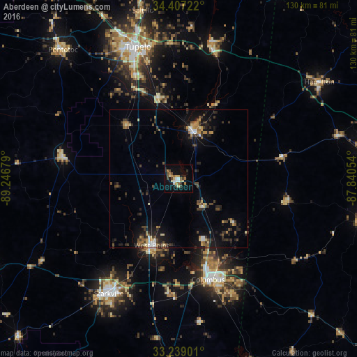
Analysis of Aberdeen night lights 2016
Square area 10x10 km:
 1.75%
1.75%90-99
2.62%80-89
3.85%70-79
2.97%60-69
3.32%50-59
2.45%40-49
4.2%30-39
1.92%20-29
3.32%10-19
16.08%0-9
57.52%Square area 50x50 km:
0.52%90-99
0.53%80-89
0.89%70-79
0.75%60-69
0.93%50-59
0.85%40-49
1.24%30-39
1.97%20-29
1.84%10-19
5.2%0-9
85.27%Clear (daylight) street map image can be seen on geolist.org.
Map coordinates:
34° 24' 26" North, 89° 14' 48.4" West
33° 49' 30.4" North, 88° 32' 37.2" West
33° 14' 20.4" North, 87° 50' 25.9" West
Some cities around Aberdeen sort by population:
• Tupelo
50.4 km =31.3 mi,  342°
342°
• Starkville
48.9 km =30.4 mi,  211°
211°
• Columbus
38.2 km =23.7 mi,  163°
163°
• West Point
26.1 km =16.2 mi,  202°
202°
• Amory
18.4 km =11.4 mi,  16°
16°
• Hamilton
62.1 km =38.6 mi,  55°
55°
• Pontotoc
63 km =39.1 mi,  318°
318°
• Saltillo
62.6 km =38.9 mi,  348°
348°
4415813 (p: 5,397)
Sources (retrieved 2019-11-25):
» Earth at Night: Flat Maps 2012, 2016