Salisbury night lights from space
Night Light of Salisbury (North Carolina) from space (United States) Src. Average luminocity for 10x10km area is 73.2395% and for 50x50km: 22.0167%.

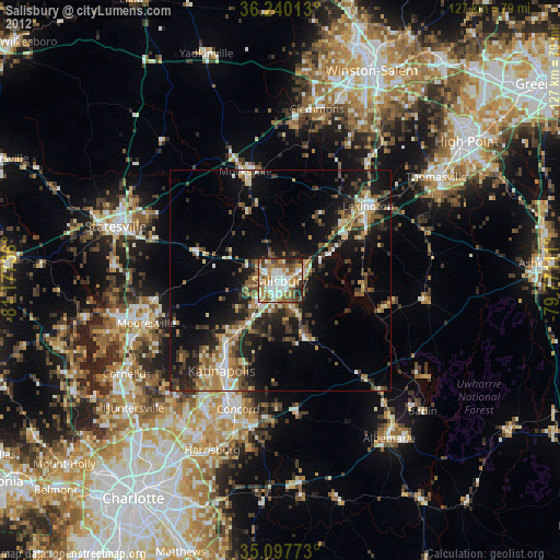
Analysis of Salisbury night lights 2016
Square area 10x10 km:
 16.78%
90-99
15.21%80-89
11.19%70-79
11.89%60-69
18.53%50-59
11.01%40-49
6.47%30-39
4.9%20-29
4.02%10-19
0%0-9
0%Square area 50x50 km:
1.76%90-99
1.94%80-89
3.34%70-79
2.95%60-69
4.24%50-59
3.14%40-49
4.28%30-39
5.98%20-29
7.39%10-19
12.96%0-9
52.03%Clear (daylight) street map image can be seen on geolist.org.
Map coordinates:
36° 14' 24.5" North, 81° 10' 38.5" West
35° 40' 15.5" North, 80° 28' 27.2" West
35° 5' 51.8" North, 79° 46' 16" West
Some cities around Salisbury sort by population:
• Concord
30.7 km =19.1 mi,  198°
198°
• Kannapolis
24.4 km =15.2 mi,  213°
213°
• Mooresville
31.8 km =19.8 mi,  252°
252°
• Statesville
39.3 km =24.4 mi,  288°
288°
• Clemmons
39.9 km =24.8 mi,  12°
12°
• Lexington
26.2 km =16.3 mi,  49°
49°
• Davidson
38 km =23.6 mi,  240°
240°
• Mocksville
26 km =16.2 mi,  342°
342°
4489985 (p: 34,017)
Sources (retrieved 2019-11-25):
» Earth at Night: Flat Maps 2012, 2016