Statesville night lights from space
Night Light of Statesville (North Carolina) from space (United States) Src. Average luminocity for 10x10km area is 66.2115% and for 50x50km: 16.7991%.
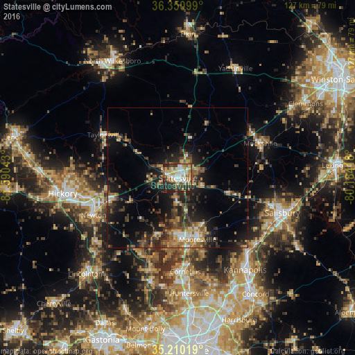

Analysis of Statesville night lights 2016
Square area 10x10 km:
 15.38%
90-99
13.81%80-89
13.29%70-79
10.14%60-69
7.17%50-59
5.24%40-49
9.44%30-39
9.27%20-29
15.56%10-19
0.7%0-9
0%Square area 50x50 km:
1.32%90-99
1.49%80-89
2.26%70-79
2.31%60-69
2.58%50-59
2.55%40-49
3.13%30-39
4.37%20-29
6.33%10-19
11.16%0-9
62.49%Clear (daylight) street map image can be seen on geolist.org.
Map coordinates:
36° 21' 3.6" North, 81° 35' 25.5" West
35° 46' 57.5" North, 80° 53' 14.3" West
35° 12' 36.7" North, 80° 11' 3" West
Some cities around Statesville sort by population:
• Mooresville
23.1 km =14.4 mi,  162°
162°
• Cornelius
33 km =20.5 mi,  175°
175°
• Newton
32.7 km =20.3 mi,  247°
247°
• Davidson
31.5 km =19.6 mi,  172°
172°
• Saint Stephens
34.9 km =21.7 mi,  266°
266°
• Conover
31.1 km =19.3 mi, 254°
• Mocksville
31.9 km =19.8 mi,  67°
67°
• Lake Norman of Catawba
22.7 km =14.1 mi,  196°
196°
4493316 (p: 26,221)
Sources (retrieved 2019-11-25):
» Earth at Night: Flat Maps 2012, 2016