Davidson night lights from space
Night Light of Davidson (North Carolina) from space (United States) Src. Average luminocity for 10x10km area is 60.8516% and for 50x50km: 47.6353%.
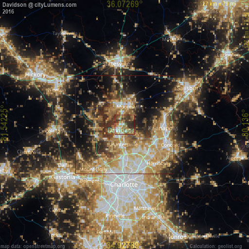
Analysis of Davidson night lights 2016
Square area 10x10 km:
 7.51%
7.51%90-99
7.51%80-89
9.71%70-79
9.52%60-69
19.23%50-59
11.36%40-49
9.34%30-39
18.86%20-29
6.96%10-19
0%0-9
0%Square area 50x50 km:
6.39%90-99
7.23%80-89
9.61%70-79
9.54%60-69
9.24%50-59
6.05%40-49
5.68%30-39
7.87%20-29
9.75%10-19
10.41%0-9
18.24%Clear (daylight) street map image can be seen on geolist.org.
Map coordinates:
36° 4' 21.7" North, 81° 32' 32.1" West
35° 30' 8.4" North, 80° 50' 20.8" West
34° 55' 40.4" North, 80° 8' 9.6" West
Some cities around Davidson sort by population:
• Concord
25.5 km =15.8 mi,  114°
114°
• Huntersville
10.2 km =6.3 mi,  181°
181°
• Kannapolis
19.7 km =12.2 mi,  94°
94°
• Mooresville
9.5 km =5.9 mi,  15°
15°
• Cornelius
2.6 km =1.6 mi,  227°
227°
• Harrisburg
25.8 km =16 mi,  140°
140°
• Mount Holly
27.8 km =17.3 mi,  215°
215°
• Lake Norman of Catawba
14.4 km =8.9 mi,  310°
310°
4463053 (p: 12,207)
Sources (retrieved 2019-11-25):
» Earth at Night: Flat Maps 2012, 2016