Lexington night lights from space
Night Light of Lexington (North Carolina) from space (United States) Src. Average luminocity for 10x10km area is 60.2955% and for 50x50km: 31.0755%.
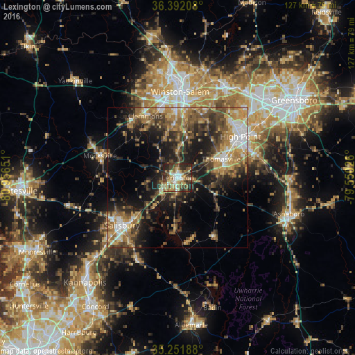
Analysis of Lexington night lights 2016
Square area 10x10 km:
 7.34%
7.34%90-99
10.31%80-89
13.99%70-79
7.34%60-69
9.97%50-59
10.14%40-49
13.46%30-39
11.36%20-29
14.51%10-19
1.57%0-9
0%Square area 50x50 km:
3.04%90-99
3.57%80-89
4.9%70-79
4.84%60-69
6.03%50-59
5.07%40-49
6.5%30-39
6.97%20-29
7.57%10-19
14.18%0-9
37.33%Clear (daylight) street map image can be seen on geolist.org.
Map coordinates:
36° 23' 31.5" North, 80° 57' 23.4" West
35° 49' 26.5" North, 80° 15' 12.2" West
35° 15' 6.8" North, 79° 33' 0.9" West
Some cities around Lexington sort by population:
• Winston-Salem
30.7 km =19.1 mi,  1°
1°
• High Point
26.7 km =16.6 mi,  56°
56°
• Salisbury
26.2 km =16.3 mi,  229°
229°
• Thomasville
16.8 km =10.4 mi,  67°
67°
• Clemmons
24.8 km =15.4 mi,  332°
332°
• Archdale
27.3 km =17 mi, 68°
• Trinity
24.9 km =15.5 mi, 71°
• Mocksville
28.8 km =17.9 mi,  285°
285°
4475773 (p: 19,326)
Sources (retrieved 2019-11-25):
» Earth at Night: Flat Maps 2012, 2016