Clemmons night lights from space
Night Light of Clemmons (North Carolina) from space (United States) Src. Average luminocity for 10x10km area is 56.7473% and for 50x50km: 32.1928%.
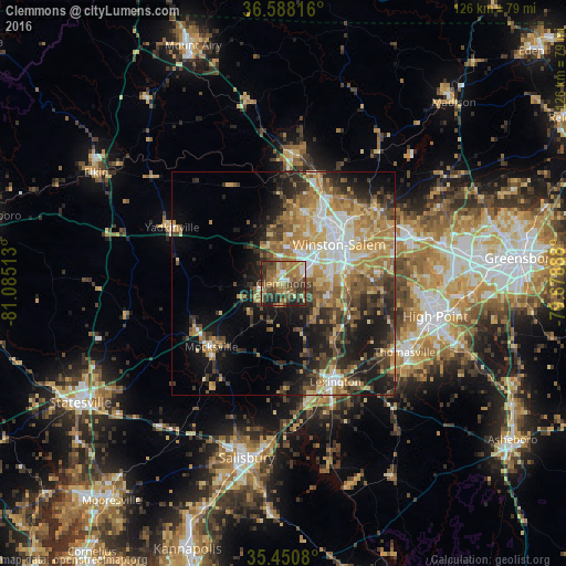
Analysis of Clemmons night lights 2016
Square area 10x10 km:
 3.66%
3.66%90-99
4.76%80-89
9.34%70-79
7.69%60-69
23.99%50-59
11.54%40-49
12.09%30-39
15.02%20-29
10.44%10-19
1.47%0-9
0%Square area 50x50 km:
3.67%90-99
4.07%80-89
5.51%70-79
5.79%60-69
7.04%50-59
4.38%40-49
5.36%30-39
5.89%20-29
7.13%10-19
12.29%0-9
38.86%Clear (daylight) street map image can be seen on geolist.org.
Map coordinates:
36° 35' 17.4" North, 81° 5' 6.5" West
36° 1' 17.5" North, 80° 22' 55.2" West
35° 27' 2.9" North, 79° 40' 44" West
Some cities around Clemmons sort by population:
• Winston-Salem
15.1 km =9.4 mi,  54°
54°
• High Point
34.7 km =21.6 mi,  102°
102°
• Thomasville
31.1 km =19.3 mi,  119°
119°
• Kernersville
29.8 km =18.5 mi,  68°
68°
• Lexington
24.8 km =15.4 mi,  152°
152°
• Lewisville
9 km =5.6 mi,  338°
338°
• King
28.9 km =18 mi,  4°
4°
• Mocksville
21.5 km =13.4 mi,  228°
228°
4461015 (p: 19,844)
Sources (retrieved 2019-11-25):
» Earth at Night: Flat Maps 2012, 2016