Saint Dennis night lights from space
Night Light of Saint Dennis (Kentucky) from space (United States) Src. Average luminocity for 10x10km area is 84.1548% and for 50x50km: 41.2108%.
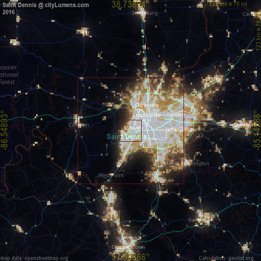
Analysis of Saint Dennis night lights 2016
Square area 10x10 km:
 34.86%
90-99
27.04%80-89
14.46%70-79
3.4%60-69
4.59%50-59
1.7%40-49
3.74%30-39
2.89%20-29
5.78%10-19
1.53%0-9
0%Square area 50x50 km:
11.82%90-99
9.94%80-89
5.65%70-79
4.69%60-69
4.87%50-59
4.07%40-49
4.18%30-39
4.28%20-29
5.04%10-19
6.18%0-9
39.27%Clear (daylight) street map image can be seen on geolist.org.
Map coordinates:
38° 44' 20.2" North, 86° 32' 56.1" West
38° 11' 18.2" North, 85° 50' 44.9" West
37° 38' 1.2" North, 85° 8' 33.6" West
Some cities around Saint Dennis sort by population:
• Louisville
10.5 km =6.5 mi,  45°
45°
• Jeffersonville
13.7 km =8.5 mi,  43°
43°
• New Albany
11 km =6.8 mi,  9°
9°
• Pleasure Ridge Park
4.9 km =3 mi,  192°
192°
• Valley Station
8.8 km =5.5 mi, 193°
• Clarksville
14.2 km =8.8 mi,  31°
31°
• Shively
2.4 km =1.5 mi,  57°
57°
• Fairdale
12 km =7.5 mi,  140°
140°
4309414 (p: 9,177)
Sources (retrieved 2019-11-25):
» Earth at Night: Flat Maps 2012, 2016