Benicia night lights from space
Night Light of Benicia (California) from space (United States) Src. Average luminocity for 10x10km area is 50.6981% and for 50x50km: 30.439%.
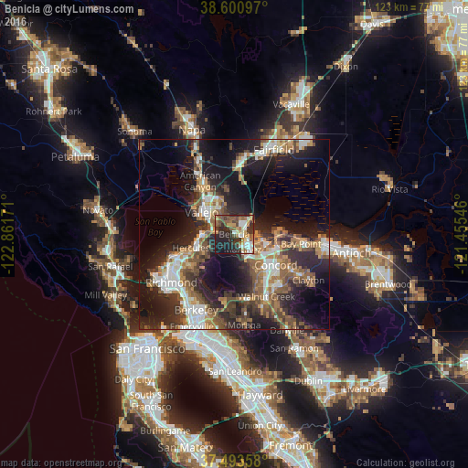

Analysis of Benicia night lights 2016
Square area 10x10 km:
 8.28%
8.28%90-99
8.93%80-89
4.22%70-79
6.66%60-69
7.63%50-59
10.71%40-49
8.6%30-39
9.25%20-29
22.24%10-19
13.31%0-9
0.16%Square area 50x50 km:
4.64%90-99
4.66%80-89
1.88%70-79
4.28%60-69
4.83%50-59
5.65%40-49
5.63%30-39
4.8%20-29
11.29%10-19
18.36%0-9
33.99%Clear (daylight) street map image can be seen on geolist.org.
Map coordinates:
38° 36' 3.5" North, 122° 51' 42.2" West
38° 2' 57.7" North, 122° 9' 30.9" West
37° 29' 36.9" North, 121° 27' 19.7" West
Some cities around Benicia sort by population:
• Concord
13.7 km =8.5 mi,  125°
125°
• Vallejo
10.5 km =6.5 mi,  305°
305°
• Martinez
4 km =2.5 mi,  147°
147°
• Pleasant Hill
14.2 km =8.8 mi,  142°
142°
• Hercules
11.9 km =7.4 mi,  252°
252°
• Pinole
13.3 km =8.3 mi, 247°
• El Sobrante
14.4 km =8.9 mi,  236°
236°
• Rodeo
9.7 km =6 mi,  259°
259°
5327550 (p: 28,167)
Sources (retrieved 2019-11-25):
» Earth at Night: Flat Maps 2012, 2016