Rochester night lights from space
Night Light of Rochester (Michigan) from space (United States) Src. Average luminocity for 10x10km area is 67.0939% and for 50x50km: 52.4473%.
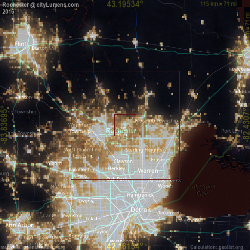
Analysis of Rochester night lights 2016
Square area 10x10 km:
 5.76%
5.76%90-99
10.76%80-89
9.85%70-79
10.91%60-69
28.64%50-59
21.52%40-49
5.91%30-39
3.79%20-29
2.88%10-19
0%0-9
0%Square area 50x50 km:
13.52%90-99
12.31%80-89
5.84%70-79
7.67%60-69
10.23%50-59
7.48%40-49
4.35%30-39
3.75%20-29
4.59%10-19
6.02%0-9
24.24%Clear (daylight) street map image can be seen on geolist.org.
Map coordinates:
43° 11' 43.2" North, 83° 50' 13" West
42° 40' 50.1" North, 83° 8' 1.8" West
42° 9' 41.5" North, 82° 25' 50.5" West
Some cities around Rochester sort by population:
• Sterling Heights
14 km =8.7 mi,  142°
142°
• Troy
8.4 km =5.2 mi,  188°
188°
• Shelby
8.3 km =5.2 mi,  97°
97°
• Pontiac
13.7 km =8.5 mi,  250°
250°
• Auburn Hills
8.2 km =5.1 mi,  275°
275°
• Birmingham
16.2 km =10.1 mi,  203°
203°
• Clawson
16.4 km =10.2 mi,  183°
183°
• Beverly Hills
18.9 km =11.7 mi, 202°
5007400 (p: 12,993)
Sources (retrieved 2019-11-25):
» Earth at Night: Flat Maps 2012, 2016