Birmingham night lights from space
Night Light of Birmingham (Michigan) from space (United States) Src. Average luminocity for 10x10km area is 82.1032% and for 50x50km: 77.511%.

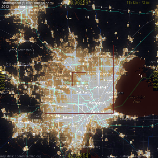
Analysis of Birmingham night lights 2016
Square area 10x10 km:
 20.32%
90-99
20.48%80-89
10.16%70-79
19.37%60-69
27.46%50-59
2.22%40-49
0%30-39
0%20-29
0%10-19
0%0-9
0%Square area 50x50 km:
30.01%90-99
18.29%80-89
7.77%70-79
9.57%60-69
11.48%50-59
7.93%40-49
4.89%30-39
2.75%20-29
2.92%10-19
3.01%0-9
1.38%Clear (daylight) street map image can be seen on geolist.org.
Map coordinates:
43° 3' 45.2" North, 83° 54' 52" West
42° 32' 48.1" North, 83° 12' 40.8" West
42° 1' 35.5" North, 82° 30' 29.5" West
Some cities around Birmingham sort by population:
• Troy
8.3 km =5.2 mi,  37°
37°
• Southfield
8.2 km =5.1 mi,  186°
186°
• Royal Oak
8.4 km =5.2 mi,  139°
139°
• Oak Park
10 km =6.2 mi,  166°
166°
• Berkley
5.4 km =3.4 mi,  154°
154°
• Clawson
5.5 km =3.4 mi,  105°
105°
• Beverly Hills
2.7 km =1.7 mi,  201°
201°
• Huntington Woods
8.2 km =5.1 mi, 153°
4986172 (p: 20,857)
Sources (retrieved 2019-11-25):
» Earth at Night: Flat Maps 2012, 2016