Robbinsdale night lights from space
Night Light of Robbinsdale (Minnesota) from space (United States) Src. Average luminocity for 10x10km area is 94.0016% and for 50x50km: 62.1782%.
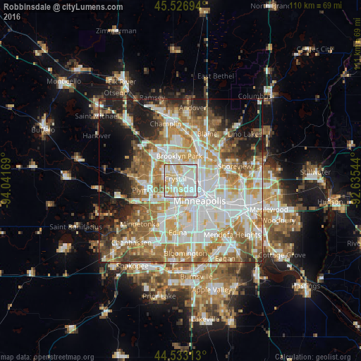
Analysis of Robbinsdale night lights 2016
Square area 10x10 km:
 39.52%
90-99
32.86%80-89
20.16%70-79
7.3%60-69
0.16%50-59
0%40-49
0%30-39
0%20-29
0%10-19
0%0-9
0%Square area 50x50 km:
17.52%90-99
14.5%80-89
7.03%70-79
8.54%60-69
10.63%50-59
7.77%40-49
5.99%30-39
3.83%20-29
5.9%10-19
9.5%0-9
8.78%Clear (daylight) street map image can be seen on geolist.org.
Map coordinates:
45° 31' 37" North, 94° 2' 30.1" West
45° 1' 55.9" North, 93° 20' 18.8" West
44° 31' 59.3" North, 92° 38' 7.6" West
Some cities around Robbinsdale sort by population:
• Minneapolis
8.3 km =5.2 mi,  134°
134°
• Brooklyn Park
7 km =4.3 mi,  348°
348°
• Brooklyn Center
4.9 km =3 mi,  5°
5°
• Fridley
8.4 km =5.2 mi,  44°
44°
• Crystal
1.7 km =1.1 mi,  272°
272°
• Golden Valley
2.6 km =1.6 mi,  198°
198°
• New Hope
3.8 km =2.4 mi,  279°
279°
• Columbia Heights
6 km =3.7 mi,  80°
80°
5043439 (p: 14,418)
Sources (retrieved 2019-11-25):
» Earth at Night: Flat Maps 2012, 2016