Crystal night lights from space
Night Light of Crystal (Minnesota) from space (United States) Src. Average luminocity for 10x10km area is 91.046% and for 50x50km: 60.5988%.

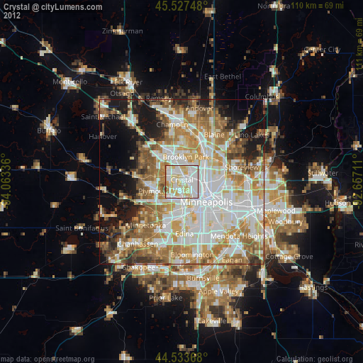
Analysis of Crystal night lights 2016
Square area 10x10 km:
 31.43%
90-99
32.22%80-89
20.32%70-79
9.05%60-69
5.56%50-59
1.43%40-49
0%30-39
0%20-29
0%10-19
0%0-9
0%Square area 50x50 km:
17.09%90-99
13.96%80-89
6.82%70-79
8.21%60-69
10.18%50-59
7.71%40-49
6.05%30-39
3.8%20-29
5.88%10-19
10.08%0-9
10.2%Clear (daylight) street map image can be seen on geolist.org.
Map coordinates:
45° 31' 38.9" North, 94° 3' 48.1" West
45° 1' 57.9" North, 93° 21' 36.8" West
44° 32' 1.2" North, 92° 39' 25.6" West
Some cities around Crystal sort by population:
• Brooklyn Park
6.8 km =4.2 mi,  2°
2°
• Plymouth
7.9 km =4.9 mi,  251°
251°
• Maple Grove
8.7 km =5.4 mi,  300°
300°
• Brooklyn Center
5.3 km =3.3 mi,  24°
24°
• Golden Valley
2.7 km =1.7 mi,  161°
161°
• New Hope
2.2 km =1.4 mi,  285°
285°
• Columbia Heights
7.7 km =4.8 mi,  83°
83°
• Robbinsdale
1.7 km =1.1 mi,  92°
92°
5023571 (p: 22,943)
Sources (retrieved 2019-11-25):
» Earth at Night: Flat Maps 2012, 2016