East Shoreham night lights from space
Night Light of East Shoreham (New York) from space (United States) Src. Average luminocity for 10x10km area is 32.648% and for 50x50km: 25.5548%.
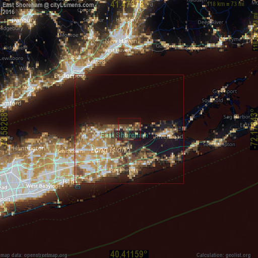
Analysis of East Shoreham night lights 2016
Square area 10x10 km:
 0.34%
0.34%90-99
0.85%80-89
4.25%70-79
3.74%60-69
5.44%50-59
7.82%40-49
12.07%30-39
7.82%20-29
19.56%10-19
27.38%0-9
10.71%Square area 50x50 km:
2.64%90-99
3.39%80-89
3.41%70-79
5.15%60-69
5.4%50-59
5.19%40-49
4.29%30-39
2.99%20-29
5.13%10-19
12.98%0-9
49.42%Clear (daylight) street map image can be seen on geolist.org.
Map coordinates:
41° 28' 25.6" North, 73° 34' 57.6" West
40° 56' 41.4" North, 72° 52' 46.4" West
40° 24' 41.7" North, 72° 10' 35.1" West
Some cities around East Shoreham sort by population:
• Manorville
9.9 km =6.2 mi,  142°
142°
• Rocky Point
3.9 km =2.4 mi,  282°
282°
• Ridge
5.8 km =3.6 mi,  193°
193°
• Miller Place
9.9 km =6.2 mi, 279°
• Middle Island
8.3 km =5.2 mi,  215°
215°
• Wading River
3.2 km =2 mi,  78°
78°
• Sound Beach
7.5 km =4.7 mi, 279°
• Calverton
12.2 km =7.6 mi,  110°
110°
5116063 (p: 6,666)
Sources (retrieved 2019-11-25):
» Earth at Night: Flat Maps 2012, 2016