River Rouge night lights from space
Night Light of River Rouge (Michigan) from space (United States) Src. Average luminocity for 10x10km area is 92.3576% and for 50x50km: 66.084%.
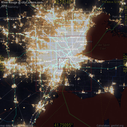
Analysis of River Rouge night lights 2016
Square area 10x10 km:
 54.24%
90-99
21.52%80-89
6.67%70-79
8.18%60-69
4.85%50-59
1.97%40-49
2.58%30-39
0%20-29
0%10-19
0%0-9
0%Square area 50x50 km:
30.91%90-99
17.99%80-89
5.34%70-79
5.21%60-69
4.12%50-59
3.06%40-49
2.79%30-39
3.06%20-29
5.63%10-19
6.59%0-9
15.31%Clear (daylight) street map image can be seen on geolist.org.
Map coordinates:
42° 47' 29.4" North, 83° 50' 15" West
42° 16' 24.1" North, 83° 8' 3.7" West
41° 45' 3.4" North, 82° 25' 52.5" West
Some cities around River Rouge sort by population:
• Detroit
9.7 km =6 mi,  48°
48°
• Dearborn
6.4 km =4 mi,  327°
327°
• Lincoln Park
4.4 km =2.7 mi,  235°
235°
• Southgate
8.2 km =5.1 mi,  216°
216°
• Allen Park
6.5 km =4 mi,  254°
254°
• Wyandotte
6.7 km =4.2 mi,  191°
191°
• Melvindale
3.5 km =2.2 mi,  286°
286°
• Ecorse
3.3 km =2.1 mi,  196°
196°
5007247 (p: 7,546)
Sources (retrieved 2019-11-25):
» Earth at Night: Flat Maps 2012, 2016