Allen Park night lights from space
Night Light of Allen Park (Michigan) from space (United States) Src. Average luminocity for 10x10km area is 98.2818% and for 50x50km: 66.7876%.

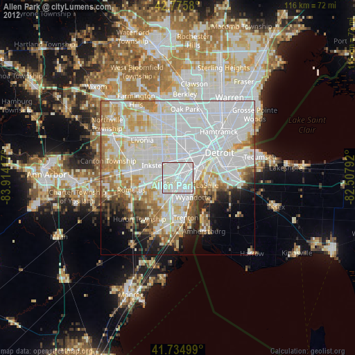
Analysis of Allen Park night lights 2016
Square area 10x10 km:
 53.48%
90-99
42.12%80-89
4.39%70-79
0%60-69
0%50-59
0%40-49
0%30-39
0%20-29
0%10-19
0%0-9
0%Square area 50x50 km:
29.8%90-99
17.83%80-89
5.87%70-79
6.04%60-69
5.38%50-59
3.86%40-49
2.94%30-39
2.77%20-29
4.83%10-19
6.08%0-9
14.61%Clear (daylight) street map image can be seen on geolist.org.
Map coordinates:
42° 46' 32.9" North, 83° 54' 51" West
42° 15' 27.1" North, 83° 12' 39.7" West
41° 44' 6" North, 82° 30' 28.5" West
Some cities around Allen Park sort by population:
• Dearborn
7.7 km =4.8 mi,  21°
21°
• Taylor
5.2 km =3.2 mi,  248°
248°
• Lincoln Park
2.8 km =1.7 mi,  106°
106°
• Southgate
5.1 km =3.2 mi,  163°
163°
• Wyandotte
7 km =4.3 mi,  133°
133°
• Melvindale
4.1 km =2.5 mi,  46°
46°
• Ecorse
5.6 km =3.5 mi, 105°
• River Rouge
6.5 km =4 mi,  74°
74°
4984016 (p: 27,425)
Sources (retrieved 2019-11-25):
» Earth at Night: Flat Maps 2012, 2016