Ripon night lights from space
Night Light of Ripon (Wisconsin) from space (United States) Src. Average luminocity for 10x10km area is 15.2397% and for 50x50km: 5.4653%.
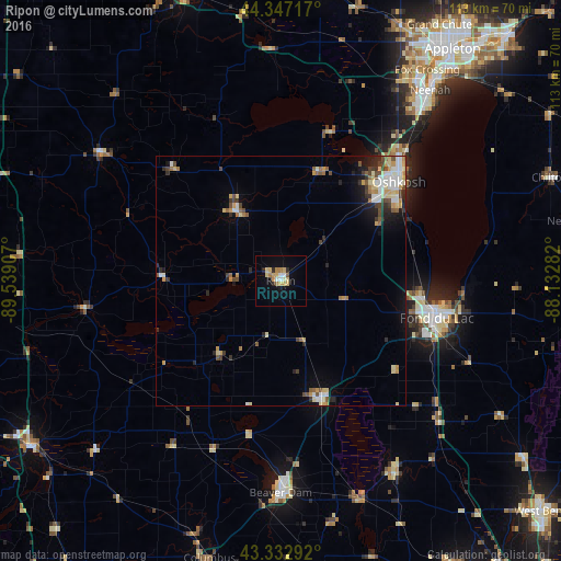
Analysis of Ripon night lights 2016
Square area 10x10 km:
 0.95%
0.95%90-99
2.06%80-89
4.44%70-79
2.7%60-69
2.38%50-59
0.79%40-49
0%30-39
0.48%20-29
2.06%10-19
3.49%0-9
80.63%Square area 50x50 km:
0.69%90-99
0.91%80-89
0.98%70-79
0.74%60-69
0.6%50-59
0.64%40-49
0.82%30-39
0.65%20-29
1.07%10-19
1.78%0-9
91.13%Clear (daylight) street map image can be seen on geolist.org.
Map coordinates:
44° 20' 49.8" North, 89° 32' 20.7" West
43° 50' 31.9" North, 88° 50' 9.4" West
43° 19' 58.5" North, 88° 7' 58.2" West
Some cities around Ripon sort by population:
• Oshkosh
31 km =19.3 mi,  49°
49°
• Fond du Lac
32.7 km =20.3 mi,  103°
103°
• Neenah
48.5 km =30.1 mi,  38°
38°
• Menasha
50.7 km =31.5 mi, 37°
• Beaver Dam
42.7 km =26.5 mi,  180°
180°
• Waupun
24.7 km =15.3 mi,  159°
159°
• Berlin
16.4 km =10.2 mi,  328°
328°
• North Fond du Lac
28.5 km =17.7 mi, 96°
5268955 (p: 7,700)
Sources (retrieved 2019-11-25):
» Earth at Night: Flat Maps 2012, 2016