Menasha night lights from space
Night Light of Menasha (Wisconsin) from space (United States) Src. Average luminocity for 10x10km area is 68.4727% and for 50x50km: 17.8514%.
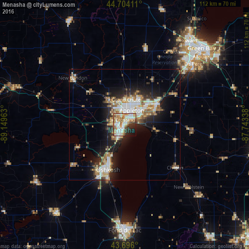
Analysis of Menasha night lights 2016
Square area 10x10 km:
 16.82%
90-99
20.15%80-89
8.18%70-79
12.42%60-69
8.94%50-59
5.45%40-49
4.09%30-39
6.52%20-29
8.64%10-19
6.67%0-9
2.12%Square area 50x50 km:
3.09%90-99
3.51%80-89
2.41%70-79
2.18%60-69
2.42%50-59
2.19%40-49
1.81%30-39
2.22%20-29
4.72%10-19
8.55%0-9
66.9%Clear (daylight) street map image can be seen on geolist.org.
Map coordinates:
44° 42' 14.8" North, 89° 8' 58.7" West
44° 12' 8" North, 88° 26' 47.4" West
43° 41' 45.6" North, 87° 44' 36.2" West
Some cities around Menasha sort by population:
• Appleton
7.1 km =4.4 mi,  20°
20°
• Oshkosh
21.2 km =13.2 mi,  201°
201°
• Neenah
2.2 km =1.4 mi,  215°
215°
• Kaukauna
16.3 km =10.1 mi,  58°
58°
• Little Chute
13.4 km =8.3 mi,  49°
49°
• Harrison
9.3 km =5.8 mi,  72°
72°
• New London
31.5 km =19.6 mi,  312°
312°
• Kimberly
11.6 km =7.2 mi, 47°
5262596 (p: 17,572)
Sources (retrieved 2019-11-25):
» Earth at Night: Flat Maps 2012, 2016