North Fond du Lac night lights from space
Night Light of North Fond du Lac (Wisconsin) from space (United States) Src. Average luminocity for 10x10km area is 37.5242% and for 50x50km: 6.9067%.
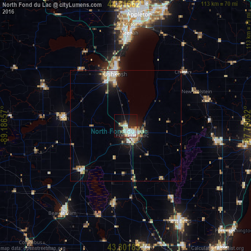
Analysis of North Fond du Lac night lights 2016
Square area 10x10 km:
 9.09%
9.09%90-99
10%80-89
6.97%70-79
0%60-69
1.97%50-59
4.09%40-49
2.58%30-39
2.27%20-29
12.12%10-19
21.67%0-9
29.24%Square area 50x50 km:
1.02%90-99
1.19%80-89
1.15%70-79
0.62%60-69
0.7%50-59
0.75%40-49
0.83%30-39
0.9%20-29
1.96%10-19
4.1%0-9
86.76%Clear (daylight) street map image can be seen on geolist.org.
Map coordinates:
44° 18' 59.8" North, 89° 11' 11.7" West
43° 48' 41" North, 88° 29' 0.4" West
43° 18' 6.6" North, 87° 46' 49.2" West
Some cities around North Fond du Lac sort by population:
• Oshkosh
24.2 km =15 mi,  348°
348°
• Fond du Lac
5.4 km =3.4 mi,  138°
138°
• Neenah
41.7 km =25.9 mi,  2°
2°
• Menasha
43.6 km =27.1 mi, 3°
• Waupun
28 km =17.4 mi,  224°
224°
• Plymouth
41.2 km =25.6 mi,  99°
99°
• Ripon
28.5 km =17.7 mi,  276°
276°
• Berlin
40.8 km =25.4 mi,  295°
295°
5264814 (p: 5,004)
Sources (retrieved 2019-11-25):
» Earth at Night: Flat Maps 2012, 2016