Beaver Dam night lights from space
Night Light of Beaver Dam (Wisconsin) from space (United States) Src. Average luminocity for 10x10km area is 25.7635% and for 50x50km: 4.0139%.
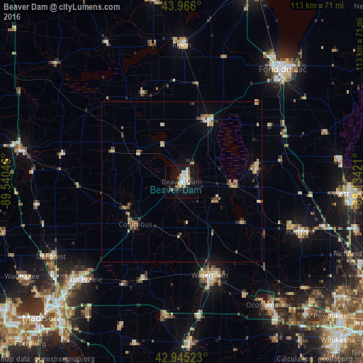
Analysis of Beaver Dam night lights 2016
Square area 10x10 km:
 5.56%
5.56%90-99
4.92%80-89
3.49%70-79
2.7%60-69
2.7%50-59
1.59%40-49
0.63%30-39
1.9%20-29
2.54%10-19
32.06%0-9
41.9%Square area 50x50 km:
0.32%90-99
0.35%80-89
0.88%70-79
0.48%60-69
0.59%50-59
0.6%40-49
0.48%30-39
0.29%20-29
0.76%10-19
1.87%0-9
93.38%Clear (daylight) street map image can be seen on geolist.org.
Map coordinates:
43° 57' 57.6" North, 89° 32' 25.7" West
43° 27' 28" North, 88° 50' 14.4" West
42° 56' 42.8" North, 88° 8' 3.2" West
Some cities around Beaver Dam sort by population:
• Sun Prairie
43.1 km =26.8 mi,  224°
224°
• Watertown
30.5 km =19 mi,  163°
163°
• Hartford
40.2 km =25 mi,  112°
112°
• Waupun
21.4 km =13.3 mi,  23°
23°
• De Forest
47.1 km =29.3 mi,  240°
240°
• Ripon
42.7 km =26.5 mi,  0°
0°
• Lake Mills
42.3 km =26.3 mi,  188°
188°
• Slinger
46.6 km =29 mi, 107°
5245193 (p: 16,564)
Sources (retrieved 2019-11-25):
» Earth at Night: Flat Maps 2012, 2016