Red Chute night lights from space
Night Light of Red Chute (Louisiana) from space (United States) Src. Average luminocity for 10x10km area is 48.5629% and for 50x50km: 25.4899%.
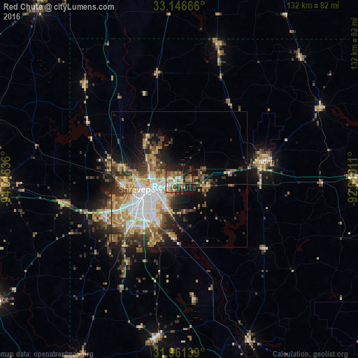
Analysis of Red Chute night lights 2016
Square area 10x10 km:
 5.42%
5.42%90-99
5.24%80-89
7.17%70-79
9.09%60-69
8.57%50-59
13.99%40-49
4.72%30-39
9.62%20-29
15.03%10-19
20.8%0-9
0.35%Square area 50x50 km:
4.87%90-99
4.48%80-89
3.25%70-79
4.04%60-69
3.84%50-59
3.72%40-49
3.02%30-39
4.67%20-29
4.85%10-19
8.01%0-9
55.27%Clear (daylight) street map image can be seen on geolist.org.
Map coordinates:
33° 8' 48" North, 94° 18' 58.9" West
32° 33' 21.5" North, 93° 36' 47.6" West
31° 57' 41" North, 92° 54' 36.4" West
Some cities around Red Chute sort by population:
• Shreveport
13.3 km =8.3 mi,  255°
255°
• Bossier City
12 km =7.5 mi,  248°
248°
• Marshall
70.7 km =43.9 mi,  268°
268°
• Minden
31.3 km =19.4 mi,  77°
77°
• Carthage
81.2 km =50.5 mi,  236°
236°
• Atlanta
80.6 km =50.1 mi,  320°
320°
• Grambling
84.3 km =52.4 mi,  92°
92°
• Springhill
51.9 km =32.2 mi,  15°
15°
4048888 (p: 6,261)
Sources (retrieved 2019-11-25):
» Earth at Night: Flat Maps 2012, 2016