Minden night lights from space
Night Light of Minden (Louisiana) from space (United States) Src. Average luminocity for 10x10km area is 41.1084% and for 50x50km: 5.0769%.
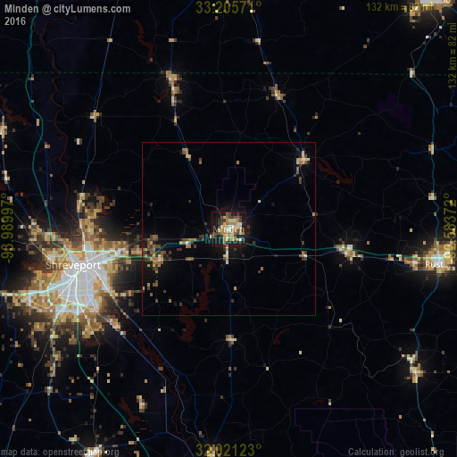
Analysis of Minden night lights 2016
Square area 10x10 km:
 2.27%
2.27%90-99
4.72%80-89
10.84%70-79
6.47%60-69
8.39%50-59
5.59%40-49
4.02%30-39
9.27%20-29
6.47%10-19
35.31%0-9
6.64%Square area 50x50 km:
0.12%90-99
0.35%80-89
0.82%70-79
0.66%60-69
0.96%50-59
0.9%40-49
0.75%30-39
1.53%20-29
0.94%10-19
3.85%0-9
89.12%Clear (daylight) street map image can be seen on geolist.org.
Map coordinates:
33° 12' 20.6" North, 93° 59' 23.9" West
32° 36' 55.5" North, 93° 17' 12.6" West
32° 1' 16.4" North, 92° 35' 1.4" West
Some cities around Minden sort by population:
• Shreveport
44.6 km =27.7 mi,  256°
256°
• Bossier City
43.2 km =26.8 mi, 255°
• Ruston
61.7 km =38.3 mi,  99°
99°
• El Dorado
87.7 km =54.5 mi,  41°
41°
• Magnolia
72.6 km =45.1 mi,  3°
3°
• Red Chute
31.3 km =19.4 mi, 257°
• Grambling
54.6 km =33.9 mi, 100°
• Springhill
46.6 km =29 mi,  338°
338°
4333533 (p: 12,690)
Sources (retrieved 2019-11-25):
» Earth at Night: Flat Maps 2012, 2016