Carthage night lights from space
Night Light of Carthage (Texas) from space (United States) Src. Average luminocity for 10x10km area is 37.1976% and for 50x50km: 4.051%.
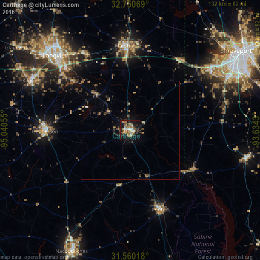
Analysis of Carthage night lights 2016
Square area 10x10 km:
 4.2%
4.2%90-99
3.5%80-89
4.9%70-79
5.42%60-69
9.44%50-59
5.24%40-49
5.07%30-39
6.12%20-29
8.04%10-19
39.69%0-9
8.39%Square area 50x50 km:
0.2%90-99
0.25%80-89
0.51%70-79
0.43%60-69
0.73%50-59
0.68%40-49
0.81%30-39
1.15%20-29
0.85%10-19
2.6%0-9
91.78%Clear (daylight) street map image can be seen on geolist.org.
Map coordinates:
32° 45' 2.5" North, 95° 2' 26" West
32° 9' 26.6" North, 94° 20' 14.7" West
31° 33' 36.6" North, 93° 38' 3.5" West
Some cities around Carthage sort by population:
• Shreveport
68.7 km =42.7 mi,  53°
53°
• Longview
53.8 km =33.4 mi,  315°
315°
• Nacogdoches
68.5 km =42.6 mi,  205°
205°
• Marshall
43.2 km =26.8 mi,  356°
356°
• Kilgore
56.7 km =35.2 mi,  296°
296°
• Henderson
43.5 km =27 mi,  269°
269°
• White Oak
64.2 km =39.9 mi,  309°
309°
• Center
42.9 km =26.7 mi,  159°
159°
4679272 (p: 6,844)
Sources (retrieved 2019-11-25):
» Earth at Night: Flat Maps 2012, 2016