Rantoul night lights from space
Night Light of Rantoul (Illinois) from space (United States) Src. Average luminocity for 10x10km area is 28.051% and for 50x50km: 8.2491%.
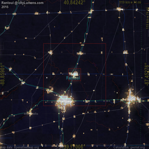
Analysis of Rantoul night lights 2016
Square area 10x10 km:
 4.42%
4.42%90-99
5.78%80-89
5.44%70-79
1.19%60-69
3.91%50-59
3.74%40-49
0.68%30-39
1.02%20-29
2.55%10-19
34.52%0-9
36.73%Square area 50x50 km:
1.53%90-99
1.61%80-89
1.22%70-79
0.86%60-69
1.06%50-59
0.74%40-49
0.78%30-39
0.85%20-29
1.62%10-19
4.13%0-9
85.6%Clear (daylight) street map image can be seen on geolist.org.
Map coordinates:
40° 50' 32.7" North, 88° 51' 32.4" West
40° 18' 30.1" North, 88° 9' 21.2" West
39° 46' 12.2" North, 87° 27' 9.9" West
Some cities around Rantoul sort by population:
• Champaign
22.6 km =14 mi,  199°
199°
• Urbana
22.4 km =13.9 mi,  191°
191°
• Danville
49.1 km =30.5 mi,  114°
114°
• Savoy
29.4 km =18.3 mi, 196°
• Mahomet
24.5 km =15.2 mi,  239°
239°
• Monticello
47.2 km =29.3 mi,  228°
228°
• Hoopeston
44.9 km =27.9 mi,  66°
66°
• Watseka
62.9 km =39.1 mi,  34°
34°
4907131 (p: 13,008)
Sources (retrieved 2019-11-25):
» Earth at Night: Flat Maps 2012, 2016