Quakertown night lights from space
Night Light of Quakertown (Pennsylvania) from space (United States) Src. Average luminocity for 10x10km area is 34.7109% and for 50x50km: 34.2199%.
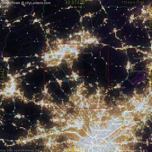
Analysis of Quakertown night lights 2016
Square area 10x10 km:
 4.25%
4.25%90-99
4.08%80-89
3.91%70-79
2.89%60-69
5.78%50-59
5.1%40-49
5.27%30-39
8.84%20-29
16.33%10-19
32.48%0-9
11.05%Square area 50x50 km:
4.39%90-99
4.98%80-89
4.21%70-79
4.96%60-69
7.7%50-59
6.34%40-49
5.91%30-39
6.09%20-29
7.27%10-19
13.27%0-9
34.87%Clear (daylight) street map image can be seen on geolist.org.
Map coordinates:
40° 58' 29.1" North, 76° 2' 40.9" West
40° 26' 30.4" North, 75° 20' 29.7" West
39° 54' 16.3" North, 74° 38' 18.4" West
Some cities around Quakertown sort by population:
• Bethlehem
20.6 km =12.8 mi,  353°
353°
• Emmaus
17 km =10.6 mi,  309°
309°
• Harleysville
18.4 km =11.4 mi,  192°
192°
• Perkasie
8.8 km =5.5 mi,  151°
151°
• Bedminster
13.9 km =8.6 mi,  97°
97°
• Kulpsville
22.1 km =13.7 mi,  178°
178°
• Souderton
14.5 km =9 mi,  174°
174°
• Hellertown
15.3 km =9.5 mi,  0°
0°
5207381 (p: 8,855)
Sources (retrieved 2019-11-25):
» Earth at Night: Flat Maps 2012, 2016