Perkasie night lights from space
Night Light of Perkasie (Pennsylvania) from space (United States) Src. Average luminocity for 10x10km area is 42.2211% and for 50x50km: 34.6938%.
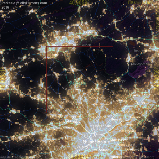
Analysis of Perkasie night lights 2016
Square area 10x10 km:
 0.85%
0.85%90-99
4.08%80-89
7.48%70-79
6.63%60-69
7.82%50-59
10.71%40-49
9.18%30-39
9.69%20-29
21.26%10-19
19.73%0-9
2.55%Square area 50x50 km:
3.14%90-99
3.96%80-89
4.67%70-79
6.06%60-69
9.7%50-59
7.67%40-49
6.14%30-39
5.86%20-29
6.46%10-19
11.65%0-9
34.69%Clear (daylight) street map image can be seen on geolist.org.
Map coordinates:
40° 54' 20.2" North, 75° 59' 44.9" West
40° 22' 19.4" North, 75° 17' 33.6" West
39° 50' 3.3" North, 74° 35' 22.4" West
Some cities around Perkasie sort by population:
• Lansdale
14.5 km =9 mi,  177°
177°
• Montgomeryville
14.5 km =9 mi,  163°
163°
• Harleysville
13 km =8.1 mi,  217°
217°
• Quakertown
8.8 km =5.5 mi,  331°
331°
• Bedminster
11.3 km =7 mi,  58°
58°
• Doylestown
15.4 km =9.6 mi,  116°
116°
• Kulpsville
14.8 km =9.2 mi,  194°
194°
• Souderton
7.2 km =4.5 mi,  202°
202°
5205638 (p: 8,471)
Sources (retrieved 2019-11-25):
» Earth at Night: Flat Maps 2012, 2016