Bedminster night lights from space
Night Light of Bedminster (Pennsylvania) from space (United States) Src. Average luminocity for 10x10km area is 7.8384% and for 50x50km: 28.2444%.
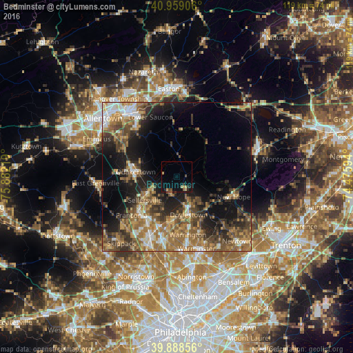
Analysis of Bedminster night lights 2016
Square area 10x10 km:
 0%
0%90-99
0%80-89
1.19%70-79
2.38%60-69
0.51%50-59
1.19%40-49
1.53%30-39
0.85%20-29
2.55%10-19
3.4%0-9
86.39%Square area 50x50 km:
2.67%90-99
3.53%80-89
3.28%70-79
4.3%60-69
6.73%50-59
5.9%40-49
5.47%30-39
5.38%20-29
6.72%10-19
12.73%0-9
43.29%Clear (daylight) street map image can be seen on geolist.org.
Map coordinates:
40° 57' 32.6" North, 75° 52' 55.9" West
40° 25' 33.4" North, 75° 10' 44.6" West
39° 53' 18.8" North, 74° 28' 33.4" West
Some cities around Bedminster sort by population:
• Lansdale
22.3 km =13.9 mi,  203°
203°
• Montgomeryville
20.6 km =12.8 mi, 195°
• Harleysville
24 km =14.9 mi,  227°
227°
• Quakertown
13.9 km =8.6 mi,  277°
277°
• Perkasie
11.3 km =7 mi,  238°
238°
• Doylestown
13.5 km =8.4 mi,  162°
162°
• Souderton
17.7 km =11 mi,  224°
224°
• Hellertown
21.9 km =13.6 mi,  321°
321°
5179641 (p: 8,402)
Sources (retrieved 2019-11-25):
» Earth at Night: Flat Maps 2012, 2016