Emmaus night lights from space
Night Light of Emmaus (Pennsylvania) from space (United States) Src. Average luminocity for 10x10km area is 56.6104% and for 50x50km: 30.215%.
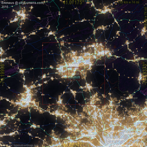
Analysis of Emmaus night lights 2016
Square area 10x10 km:
 7.95%
7.95%90-99
8.93%80-89
9.25%70-79
11.36%60-69
13.47%50-59
9.25%40-49
4.06%30-39
8.93%20-29
13.8%10-19
12.66%0-9
0.32%Square area 50x50 km:
4.55%90-99
4.68%80-89
3.29%70-79
4.07%60-69
5.52%50-59
5.16%40-49
4.37%30-39
5.24%20-29
7.21%10-19
15.23%0-9
40.7%Clear (daylight) street map image can be seen on geolist.org.
Map coordinates:
41° 4' 18.3" North, 76° 11' 59.9" West
40° 32' 22.3" North, 75° 29' 48.7" West
40° 0' 11.1" North, 74° 47' 37.4" West
Some cities around Emmaus sort by population:
• Allentown
7.7 km =4.8 mi,  4°
4°
• Whitehall Township
14.1 km =8.8 mi,  358°
358°
• Fullerton
10.4 km =6.5 mi,  11°
11°
• Ancient Oaks
7.9 km =4.9 mi,  276°
276°
• Catasauqua
13 km =8.1 mi, 8°
• Red Lion
12 km =7.5 mi,  236°
236°
• Wescosville
5.6 km =3.5 mi,  302°
302°
• Hellertown
13.9 km =8.6 mi,  71°
71°
5188726 (p: 11,368)
Sources (retrieved 2019-11-25):
» Earth at Night: Flat Maps 2012, 2016