Purcellville night lights from space
Night Light of Purcellville (Virginia) from space (United States) Src. Average luminocity for 10x10km area is 20.9075% and for 50x50km: 15.7558%.
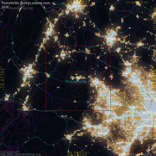
Analysis of Purcellville night lights 2016
Square area 10x10 km:
 0.16%
0.16%90-99
1.79%80-89
3.57%70-79
5.19%60-69
2.11%50-59
4.38%40-49
2.27%30-39
3.73%20-29
3.9%10-19
13.31%0-9
59.58%Square area 50x50 km:
2.53%90-99
2.72%80-89
2.1%70-79
2.59%60-69
2.37%50-59
1.97%40-49
1.57%30-39
2.4%20-29
3.21%10-19
6.74%0-9
71.8%Clear (daylight) street map image can be seen on geolist.org.
Map coordinates:
39° 40' 48.1" North, 78° 25' 4.3" West
39° 8' 12.4" North, 77° 42' 53" West
38° 35' 21.4" North, 77° 0' 41.8" West
Some cities around Purcellville sort by population:
• Leesburg
13.2 km =8.2 mi,  100°
100°
• Ashburn
22.2 km =13.8 mi,  117°
117°
• Broadlands
21.3 km =13.2 mi,  128°
128°
• Brambleton
23 km =14.3 mi,  138°
138°
• Brunswick
21.1 km =13.1 mi,  20°
20°
• Belmont
19.4 km =12.1 mi,  114°
114°
• Charles Town
21 km =13 mi,  323°
323°
• Poolesville
25.7 km =16 mi,  87°
87°
4780641 (p: 9,232)
Sources (retrieved 2019-11-25):
» Earth at Night: Flat Maps 2012, 2016