Charles Town night lights from space
Night Light of Charles Town (West Virginia) from space (United States) Src. Average luminocity for 10x10km area is 31.0357% and for 50x50km: 11.7254%.
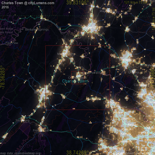
Analysis of Charles Town night lights 2016
Square area 10x10 km:
 3.23%
3.23%90-99
2.89%80-89
4.42%70-79
5.1%60-69
4.93%50-59
5.95%40-49
3.4%30-39
4.25%20-29
6.8%10-19
35.88%0-9
23.13%Square area 50x50 km:
0.82%90-99
1.05%80-89
1.62%70-79
1.55%60-69
1.74%50-59
1.8%40-49
1.86%30-39
2.46%20-29
3.77%10-19
8.85%0-9
74.49%Clear (daylight) street map image can be seen on geolist.org.
Map coordinates:
39° 49' 51.8" North, 78° 33' 46.3" West
39° 17' 20.4" North, 77° 51' 35" West
38° 44' 33.7" North, 77° 9' 23.8" West
Some cities around Charles Town sort by population:
• Leesburg
32 km =19.9 mi,  127°
127°
• Winchester
28.6 km =17.8 mi,  246°
246°
• Ballenger Creek
37.7 km =23.4 mi,  75°
75°
• Martinsburg
20.6 km =12.8 mi,  334°
334°
• Halfway
37.9 km =23.5 mi,  13°
13°
• Purcellville
21 km =13 mi,  143°
143°
• Brunswick
20.2 km =12.6 mi, 81°
• Belmont
39.1 km =24.3 mi, 129°
4801850 (p: 5,899)
Sources (retrieved 2019-11-25):
» Earth at Night: Flat Maps 2012, 2016