Poolesville night lights from space
Night Light of Poolesville (Maryland) from space (United States) Src. Average luminocity for 10x10km area is 12.1705% and for 50x50km: 37.031%.
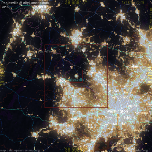
Analysis of Poolesville night lights 2016
Square area 10x10 km:
 0.16%
0.16%90-99
1.14%80-89
1.95%70-79
0.32%60-69
0.65%50-59
0.97%40-49
1.95%30-39
1.46%20-29
5.84%10-19
18.67%0-9
66.88%Square area 50x50 km:
6.45%90-99
6.75%80-89
4.56%70-79
6.7%60-69
6.94%50-59
6.15%40-49
4.31%30-39
4.19%20-29
6.14%10-19
12.17%0-9
35.65%Clear (daylight) street map image can be seen on geolist.org.
Map coordinates:
39° 41' 20.9" North, 78° 7' 12.2" West
39° 8' 45.4" North, 77° 25' 0.9" West
38° 35' 54.7" North, 76° 42' 49.7" West
Some cities around Poolesville sort by population:
• Germantown
12.9 km =8 mi,  76°
76°
• Leesburg
13.1 km =8.1 mi,  255°
255°
• Ashburn
12.9 km =8 mi,  208°
208°
• Sugarland Run
12.6 km =7.8 mi,  163°
163°
• Lowes Island
11.1 km =6.9 mi,  149°
149°
• Countryside
11.7 km =7.3 mi,  178°
178°
• Darnestown
11.9 km =7.4 mi,  113°
113°
• Belmont
12.1 km =7.5 mi,  221°
221°
4365877 (p: 5,201)
Sources (retrieved 2019-11-25):
» Earth at Night: Flat Maps 2012, 2016