Brambleton night lights from space
Night Light of Brambleton (Virginia) from space (United States) Src. Average luminocity for 10x10km area is 58.9773% and for 50x50km: 39.5544%.
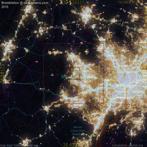
Analysis of Brambleton night lights 2016
Square area 10x10 km:
 8.6%
8.6%90-99
10.06%80-89
7.63%70-79
11.2%60-69
12.34%50-59
13.31%40-49
8.28%30-39
7.47%20-29
11.85%10-19
8.93%0-9
0.32%Square area 50x50 km:
7.16%90-99
7.97%80-89
4.99%70-79
7.26%60-69
8.17%50-59
5.46%40-49
4.04%30-39
4.9%20-29
6.22%10-19
7.96%0-9
35.88%Clear (daylight) street map image can be seen on geolist.org.
Map coordinates:
39° 31' 35.4" North, 78° 14' 30.2" West
38° 58' 55.4" North, 77° 32' 19" West
38° 26' 0.1" North, 76° 50' 7.7" West
Some cities around Brambleton sort by population:
• Ashburn
8.2 km =5.1 mi,  32°
32°
• Sterling
9.9 km =6.2 mi,  74°
74°
• Herndon
13.3 km =8.3 mi,  96°
96°
• South Riding
7.4 km =4.6 mi,  156°
156°
• Broadlands
4.3 km =2.7 mi,  21°
21°
• Countryside
12.6 km =7.8 mi,  58°
58°
• Floris
12 km =7.5 mi,  114°
114°
• Belmont
9.5 km =5.9 mi, 15°
4748703 (p: 9,845)
Sources (retrieved 2019-11-25):
» Earth at Night: Flat Maps 2012, 2016