Broadlands night lights from space
Night Light of Broadlands (Virginia) from space (United States) Src. Average luminocity for 10x10km area is 68.1445% and for 50x50km: 37.8819%.
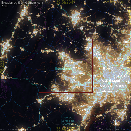
Analysis of Broadlands night lights 2016
Square area 10x10 km:
 11.85%
90-99
19.81%80-89
11.53%70-79
13.64%60-69
9.25%50-59
3.25%40-49
5.03%30-39
10.88%20-29
12.66%10-19
2.11%0-9
0%Square area 50x50 km:
6.98%90-99
7.57%80-89
4.82%70-79
6.9%60-69
7.81%50-59
5.36%40-49
3.72%30-39
4.51%20-29
5.87%10-19
7.56%0-9
38.9%Clear (daylight) street map image can be seen on geolist.org.
Map coordinates:
39° 33' 44.4" North, 78° 13' 24.2" West
39° 1' 5.4" North, 77° 31' 13" West
38° 28' 11.1" North, 76° 49' 1.7" West
Some cities around Broadlands sort by population:
• Leesburg
11.5 km =7.1 mi,  340°
340°
• Ashburn
4 km =2.5 mi,  44°
44°
• Sterling
8 km =5 mi,  99°
99°
• South Riding
10.9 km =6.8 mi,  172°
172°
• Sugarland Run
12.7 km =7.9 mi,  80°
80°
• Countryside
9.6 km =6 mi,  74°
74°
• Brambleton
4.3 km =2.7 mi,  201°
201°
• Belmont
5.3 km =3.3 mi,  9°
9°
4749103 (p: 12,313)
Sources (retrieved 2019-11-25):
» Earth at Night: Flat Maps 2012, 2016