Prairie Ridge night lights from space
Night Light of Prairie Ridge (Washington) from space (United States) Src. Average luminocity for 10x10km area is 23.0938% and for 50x50km: 23.4539%.
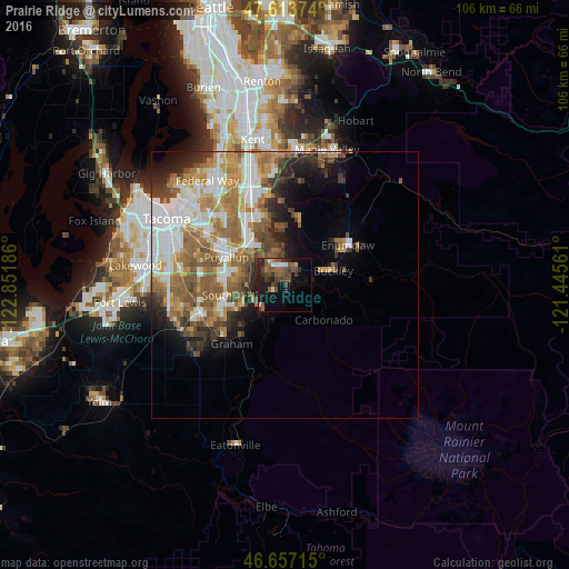
Analysis of Prairie Ridge night lights 2016
Square area 10x10 km:
 1.99%
1.99%90-99
2.41%80-89
0.71%70-79
0.57%60-69
3.13%50-59
7.81%40-49
8.66%30-39
6.11%20-29
5.97%10-19
17.19%0-9
45.45%Square area 50x50 km:
5.12%90-99
4.31%80-89
1.85%70-79
3.5%60-69
4.55%50-59
4.92%40-49
3.12%30-39
2.57%20-29
3.4%10-19
5.23%0-9
61.43%Clear (daylight) street map image can be seen on geolist.org.
Map coordinates:
47° 36' 49.5" North, 122° 51' 6.7" West
47° 8' 15.4" North, 122° 8' 55.4" West
46° 39' 25.7" North, 121° 26' 44.2" West
Some cities around Prairie Ridge sort by population:
• South Hill
9.2 km =5.7 mi,  272°
272°
• Puyallup
12.1 km =7.5 mi,  295°
295°
• Graham
14.5 km =9 mi,  229°
229°
• Bonney Lake
5.2 km =3.2 mi,  326°
326°
• Enumclaw
14 km =8.7 mi,  58°
58°
• Sumner
10.1 km =6.3 mi,  316°
316°
• Orting
6.1 km =3.8 mi,  223°
223°
• Summit View
15.4 km =9.6 mi, 269°
5807367 (p: 11,464)
Sources (retrieved 2019-11-25):
» Earth at Night: Flat Maps 2012, 2016