Summit View night lights from space
Night Light of Summit View (Washington) from space (United States) Src. Average luminocity for 10x10km area is 66.0696% and for 50x50km: 32.1835%.
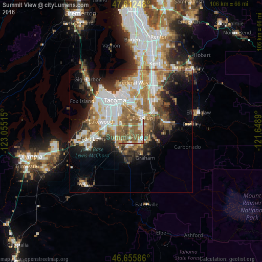
Analysis of Summit View night lights 2016
Square area 10x10 km:
 7.39%
7.39%90-99
11.36%80-89
4.69%70-79
8.52%60-69
16.48%50-59
39.06%40-49
10.8%30-39
1.7%20-29
0%10-19
0%0-9
0%Square area 50x50 km:
7.4%90-99
6.32%80-89
2.61%70-79
4.42%60-69
5.66%50-59
5.8%40-49
3.83%30-39
3.57%20-29
5.77%10-19
8.86%0-9
45.76%Clear (daylight) street map image can be seen on geolist.org.
Map coordinates:
47° 36' 44.9" North, 123° 3' 18.5" West
47° 8' 10.8" North, 122° 21' 7.3" West
46° 39' 21.1" North, 121° 38' 56" West
Some cities around Summit View sort by population:
• South Hill
6.2 km =3.9 mi,  84°
84°
• Puyallup
7.1 km =4.4 mi,  39°
39°
• Parkland
6.6 km =4.1 mi,  288°
288°
• Spanaway
7.2 km =4.5 mi,  240°
240°
• Frederickson
4.5 km =2.8 mi,  186°
186°
• Elk Plain
9.9 km =6.2 mi,  200°
200°
• Midland
5.3 km =3.3 mi,  310°
310°
• Waller
7.3 km =4.5 mi,  349°
349°
7315426 (p: 7,236)
Sources (retrieved 2019-11-25):
» Earth at Night: Flat Maps 2012, 2016