Port Lavaca night lights from space
Night Light of Port Lavaca (Texas) from space (United States) Src. Average luminocity for 10x10km area is 29.2235% and for 50x50km: 5.1567%.
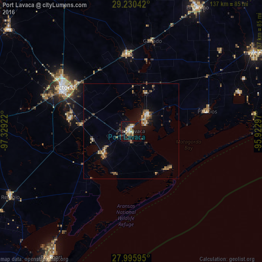
Analysis of Port Lavaca night lights 2016
Square area 10x10 km:
 3.22%
3.22%90-99
3.6%80-89
6.44%70-79
3.79%60-69
0.57%50-59
4.17%40-49
3.6%30-39
3.6%20-29
4.55%10-19
48.3%0-9
18.18%Square area 50x50 km:
0.34%90-99
0.4%80-89
0.77%70-79
0.76%60-69
0.55%50-59
0.78%40-49
0.85%30-39
1.08%20-29
0.98%10-19
4.22%0-9
89.25%Clear (daylight) street map image can be seen on geolist.org.
Map coordinates:
29° 13' 49.5" North, 97° 19' 45.2" West
28° 36' 54" North, 96° 37' 33.9" West
27° 59' 45.4" North, 95° 55' 22.7" West
Some cities around Port Lavaca sort by population:
• Victoria
42.5 km =26.4 mi,  299°
299°
• Bay City
75.9 km =47.2 mi,  57°
57°
• El Campo
73.4 km =45.6 mi,  28°
28°
• Rockport
78.3 km =48.7 mi,  212°
212°
• Wharton
92.7 km =57.6 mi, 33°
• Cuero
83.7 km =52 mi,  309°
309°
• Yoakum
90.6 km =56.3 mi,  325°
325°
• Edna
40.5 km =25.2 mi,  357°
357°
4720067 (p: 12,416)
Sources (retrieved 2019-11-25):
» Earth at Night: Flat Maps 2012, 2016