Bay City night lights from space
Night Light of Bay City (Texas) from space (United States) Src. Average luminocity for 10x10km area is 41.0774% and for 50x50km: 4.9845%.
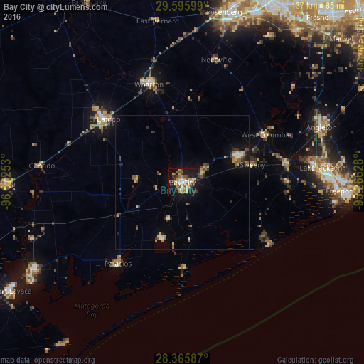
Analysis of Bay City night lights 2016
Square area 10x10 km:
 3.37%
3.37%90-99
3.97%80-89
11.9%70-79
8.73%60-69
3.57%50-59
5.56%40-49
4.56%30-39
6.35%20-29
6.94%10-19
39.29%0-9
5.75%Square area 50x50 km:
0.32%90-99
0.38%80-89
0.99%70-79
0.78%60-69
0.48%50-59
0.69%40-49
0.62%30-39
1.02%20-29
1.06%10-19
3.81%0-9
89.86%Clear (daylight) street map image can be seen on geolist.org.
Map coordinates:
29° 35' 45.6" North, 96° 40' 21.1" West
28° 58' 57.9" North, 95° 58' 9.8" West
28° 21' 57.1" North, 95° 15' 58.6" West
Some cities around Bay City sort by population:
• Rosenberg
65.7 km =40.8 mi,  13°
13°
• Lake Jackson
52.3 km =32.5 mi,  83°
83°
• Angleton
56.2 km =34.9 mi,  68°
68°
• Freeport
59.4 km =36.9 mi,  93°
93°
• El Campo
37.6 km =23.4 mi,  309°
309°
• Clute
55.7 km =34.6 mi, 85°
• Wharton
38.8 km =24.1 mi,  340°
340°
• Edna
65.8 km =40.9 mi,  269°
269°
4829307 (p: 17,598)
Sources (retrieved 2019-11-25):
» Earth at Night: Flat Maps 2012, 2016