Port Allen night lights from space
Night Light of Port Allen (Louisiana) from space (United States) Src. Average luminocity for 10x10km area is 87.359% and for 50x50km: 45.1371%.
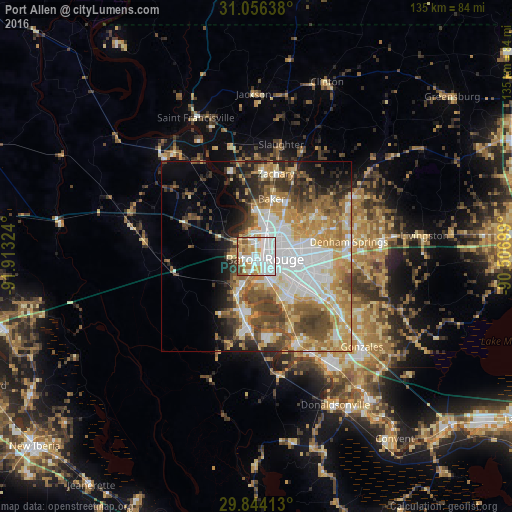
Analysis of Port Allen night lights 2016
Square area 10x10 km:
 37.91%
90-99
23.99%80-89
6.96%70-79
13.37%60-69
7.51%50-59
5.13%40-49
4.21%30-39
0.92%20-29
0%10-19
0%0-9
0%Square area 50x50 km:
10.74%90-99
7.77%80-89
6.79%70-79
7.87%60-69
7.07%50-59
5.52%40-49
7.14%30-39
4.93%20-29
4.97%10-19
6.12%0-9
31.08%Clear (daylight) street map image can be seen on geolist.org.
Map coordinates:
31° 3' 23" North, 91° 54' 47.7" West
30° 27' 7.7" North, 91° 12' 36.4" West
29° 50' 38.9" North, 90° 30' 25.2" West
Some cities around Port Allen sort by population:
• Baton Rouge
2.4 km =1.5 mi,  114°
114°
• Baker
15.7 km =9.8 mi,  14°
14°
• Gardere
13.6 km =8.5 mi,  150°
150°
• Merrydale
11.2 km =7 mi,  60°
60°
• Oak Hills Place
15.6 km =9.7 mi,  131°
131°
• Inniswold
13.2 km =8.2 mi, 113°
• Brownsfield
13.6 km =8.5 mi,  39°
39°
• Monticello
16 km =9.9 mi,  75°
75°
4337823 (p: 5,130)
Sources (retrieved 2019-11-25):
» Earth at Night: Flat Maps 2012, 2016