Brownsfield night lights from space
Night Light of Brownsfield (Louisiana) from space (United States) Src. Average luminocity for 10x10km area is 79.9304% and for 50x50km: 45.0854%.
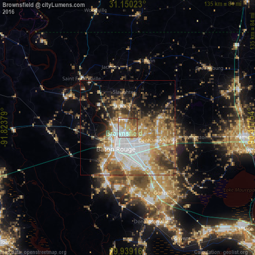
Analysis of Brownsfield night lights 2016
Square area 10x10 km:
 19.96%
90-99
17.03%80-89
10.99%70-79
29.12%60-69
8.97%50-59
6.96%40-49
5.31%30-39
1.47%20-29
0.18%10-19
0%0-9
0%Square area 50x50 km:
9.9%90-99
7.3%80-89
6.77%70-79
7.66%60-69
8.74%50-59
5.6%40-49
5.74%30-39
5.84%20-29
5.58%10-19
8.06%0-9
28.8%Clear (daylight) street map image can be seen on geolist.org.
Map coordinates:
31° 9' 0.8" North, 91° 49' 25.6" West
30° 32' 47.7" North, 91° 7' 14.4" West
29° 56' 21" North, 90° 25' 3.1" West
Some cities around Brownsfield sort by population:
• Baton Rouge
13.1 km =8.1 mi,  209°
209°
• Central
8.1 km =5 mi,  83°
83°
• Zachary
11.8 km =7.3 mi,  343°
343°
• Baker
6.5 km =4 mi,  315°
315°
• Merrydale
5.2 km =3.2 mi,  166°
166°
• Inniswold
16.2 km =10.1 mi, 167°
• Monticello
9.4 km =5.8 mi,  132°
132°
• Port Allen
13.6 km =8.5 mi,  219°
219°
4318037 (p: 5,401)
Sources (retrieved 2019-11-25):
» Earth at Night: Flat Maps 2012, 2016