Gardere night lights from space
Night Light of Gardere (Louisiana) from space (United States) Src. Average luminocity for 10x10km area is 69.859% and for 50x50km: 51.794%.
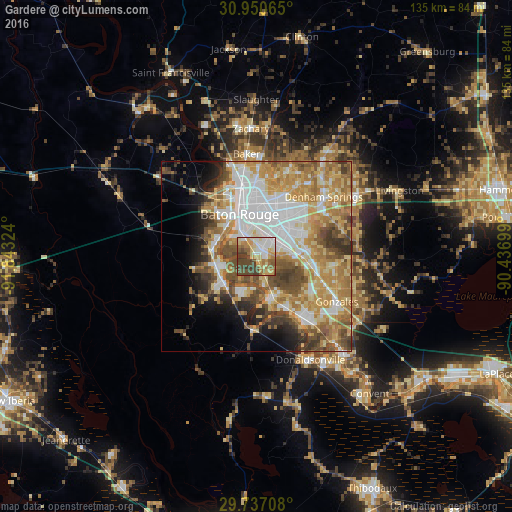
Analysis of Gardere night lights 2016
Square area 10x10 km:
 11.17%
90-99
14.47%80-89
14.65%70-79
10.81%60-69
9.71%50-59
10.44%40-49
19.78%30-39
8.97%20-29
0%10-19
0%0-9
0%Square area 50x50 km:
11.39%90-99
8.6%80-89
9.15%70-79
10.05%60-69
9.8%50-59
6.22%40-49
7.66%30-39
4.61%20-29
3.75%10-19
5.18%0-9
23.6%Clear (daylight) street map image can be seen on geolist.org.
Map coordinates:
30° 57' 2.3" North, 91° 50' 35.7" West
30° 20' 44.7" North, 91° 8' 24.4" West
29° 44' 13.5" North, 90° 26' 13.2" West
Some cities around Gardere sort by population:
• Baton Rouge
11.8 km =7.3 mi,  337°
337°
• Oak Hills Place
5.3 km =3.3 mi,  72°
72°
• Village Saint George
7.2 km =4.5 mi,  75°
75°
• Old Jefferson
12.5 km =7.8 mi, 70°
• Plaquemine
11 km =6.8 mi,  235°
235°
• Saint Gabriel
10.5 km =6.5 mi,  158°
158°
• Inniswold
8.5 km =5.3 mi,  39°
39°
• Port Allen
13.6 km =8.5 mi,  330°
330°
4325507 (p: 10,580)
Sources (retrieved 2019-11-25):
» Earth at Night: Flat Maps 2012, 2016