Merrydale night lights from space
Night Light of Merrydale (Louisiana) from space (United States) Src. Average luminocity for 10x10km area is 92.2509% and for 50x50km: 50.6931%.
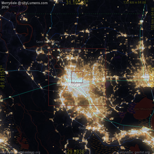
Analysis of Merrydale night lights 2016
Square area 10x10 km:
 47.44%
90-99
21.25%80-89
10.62%70-79
17.22%60-69
3.48%50-59
0%40-49
0%30-39
0%20-29
0%10-19
0%0-9
0%Square area 50x50 km:
10.29%90-99
7.75%80-89
8.19%70-79
9.02%60-69
10.14%50-59
6.55%40-49
8.13%30-39
6.47%20-29
5.87%10-19
8.2%0-9
19.41%Clear (daylight) street map image can be seen on geolist.org.
Map coordinates:
31° 6' 18.8" North, 91° 48' 41.7" West
30° 30' 4.7" North, 91° 6' 30.4" West
29° 53' 37" North, 90° 24' 19.2" West
Some cities around Merrydale sort by population:
• Baton Rouge
9.9 km =6.2 mi,  229°
229°
• Central
9.1 km =5.7 mi,  49°
49°
• Baker
11.2 km =7 mi,  329°
329°
• Denham Springs
14.5 km =9 mi,  96°
96°
• Inniswold
11 km =6.8 mi,  167°
167°
• Brownsfield
5.2 km =3.2 mi,  346°
346°
• Monticello
5.9 km =3.7 mi, 103°
• Port Allen
11.2 km =7 mi,  240°
240°
4333161 (p: 9,772)
Sources (retrieved 2019-11-25):
» Earth at Night: Flat Maps 2012, 2016