Monticello night lights from space
Night Light of Monticello (Louisiana) from space (United States) Src. Average luminocity for 10x10km area is 87.2601% and for 50x50km: 54.2022%.
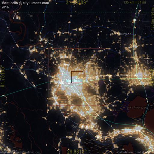
Analysis of Monticello night lights 2016
Square area 10x10 km:
 28.94%
90-99
19.6%80-89
15.93%70-79
28.21%60-69
7.33%50-59
0%40-49
0%30-39
0%20-29
0%10-19
0%0-9
0%Square area 50x50 km:
10.69%90-99
8.08%80-89
8.72%70-79
9.53%60-69
10.67%50-59
7.28%40-49
8.92%30-39
7.15%20-29
7.92%10-19
10.6%0-9
10.43%Clear (daylight) street map image can be seen on geolist.org.
Map coordinates:
31° 5' 35.1" North, 91° 45' 6.7" West
30° 29' 20.7" North, 91° 2' 55.4" West
29° 52' 52.7" North, 90° 20' 44.2" West
Some cities around Monticello sort by population:
• Central
7.3 km =4.5 mi,  8°
8°
• Shenandoah
10.8 km =6.7 mi,  154°
154°
• Denham Springs
8.7 km =5.4 mi,  91°
91°
• Merrydale
5.9 km =3.7 mi,  283°
283°
• Village Saint George
14.2 km =8.8 mi,  187°
187°
• Old Jefferson
12.2 km =7.6 mi,  165°
165°
• Inniswold
9.9 km =6.2 mi,  199°
199°
• Brownsfield
9.4 km =5.8 mi,  312°
312°
4333718 (p: 5,172)
Sources (retrieved 2019-11-25):
» Earth at Night: Flat Maps 2012, 2016