Poplar Bluff night lights from space
Night Light of Poplar Bluff (Missouri) from space (United States) Src. Average luminocity for 10x10km area is 41.1713% and for 50x50km: 3.2712%.
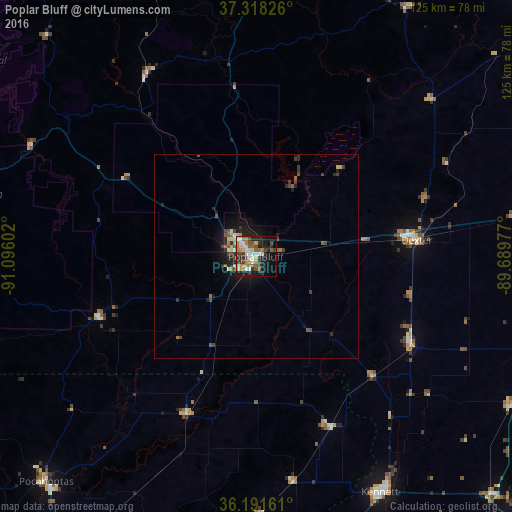
Analysis of Poplar Bluff night lights 2016
Square area 10x10 km:
 5.59%
5.59%90-99
6.47%80-89
6.47%70-79
5.94%60-69
7.52%50-59
6.12%40-49
4.9%30-39
9.27%20-29
4.72%10-19
26.05%0-9
16.96%Square area 50x50 km:
0.26%90-99
0.39%80-89
0.44%70-79
0.3%60-69
0.48%50-59
0.48%40-49
0.7%30-39
0.82%20-29
0.69%10-19
2.75%0-9
92.69%Clear (daylight) street map image can be seen on geolist.org.
Map coordinates:
37° 19' 5.7" North, 91° 5' 45.7" West
36° 45' 25.2" North, 90° 23' 34.4" West
36° 11' 29.8" North, 89° 41' 23.2" West
Some cities around Poplar Bluff sort by population:
• Paragould
78.2 km =48.6 mi,  186°
186°
• Sikeston
72.9 km =45.3 mi,  79°
79°
• Jackson
94.8 km =58.9 mi,  42°
42°
• Kennett
65.3 km =40.6 mi,  152°
152°
• Dexter
39 km =24.2 mi, 83°
• Pocahontas
75.5 km =46.9 mi,  223°
223°
• Caruthersville
91 km =56.5 mi,  133°
133°
• Charleston
94.5 km =58.7 mi, 78°
4404233 (p: 17,266)
Sources (retrieved 2019-11-25):
» Earth at Night: Flat Maps 2012, 2016