Mount Kisco night lights from space
Night Light of Mount Kisco (New York) from space (United States) Src. Average luminocity for 10x10km area is 29.7321% and for 50x50km: 36.875%.
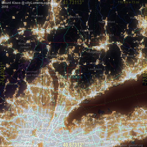
Analysis of Mount Kisco night lights 2016
Square area 10x10 km:
 1.62%
1.62%90-99
4.22%80-89
2.92%70-79
4.22%60-69
1.46%50-59
5.19%40-49
4.87%30-39
6.17%20-29
13.64%10-19
47.56%0-9
8.12%Square area 50x50 km:
3.73%90-99
4.69%80-89
4.75%70-79
6.03%60-69
8.12%50-59
7.43%40-49
5.97%30-39
6.4%20-29
9.99%10-19
18.52%0-9
24.38%Clear (daylight) street map image can be seen on geolist.org.
Map coordinates:
41° 43' 52.1" North, 74° 25' 48.8" West
41° 12' 15.3" North, 73° 43' 37.5" West
40° 40' 23.2" North, 73° 1' 26.3" West
Some cities around Mount Kisco sort by population:
• Ossining
12.2 km =7.6 mi,  247°
247°
• Jefferson Valley-Yorktown
14.1 km =8.8 mi,  334°
334°
• North Castle
8 km =5 mi,  153°
153°
• Croton-on-Hudson
13.7 km =8.5 mi,  271°
271°
• Briarcliff Manor
10.4 km =6.5 mi,  231°
231°
• Pleasantville
9.6 km =6 mi,  214°
214°
• Lake Mohegan
16.1 km =10 mi,  321°
321°
• Pound Ridge
12.7 km =7.9 mi,  87°
87°
5127744 (p: 11,145)
Sources (retrieved 2019-11-25):
» Earth at Night: Flat Maps 2012, 2016