Plainville night lights from space
Night Light of Plainville (Massachusetts) from space (United States) Src. Average luminocity for 10x10km area is 47.7841% and for 50x50km: 44.2287%.
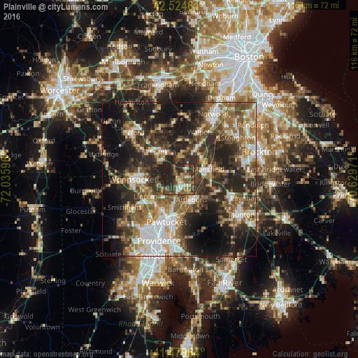
Analysis of Plainville night lights 2016
Square area 10x10 km:
 4.29%
4.29%90-99
4.6%80-89
4.92%70-79
5.87%60-69
10%50-59
11.9%40-49
14.44%30-39
12.38%20-29
22.22%10-19
9.37%0-9
0%Square area 50x50 km:
6.89%90-99
7.3%80-89
4.59%70-79
4.71%60-69
7.06%50-59
9.07%40-49
8.55%30-39
8.99%20-29
14.41%10-19
16.88%0-9
11.56%Clear (daylight) street map image can be seen on geolist.org.
Map coordinates:
42° 31' 28.6" North, 72° 2' 9.5" West
42° 0' 15.4" North, 71° 19' 58.2" West
41° 28' 46.7" North, 70° 37' 47" West
Some cities around Plainville sort by population:
• Attleboro
7.7 km =4.8 mi,  149°
149°
• Cumberland
9.3 km =5.8 mi,  243°
243°
• Franklin
10.3 km =6.4 mi,  329°
329°
• Mansfield
10 km =6.2 mi,  70°
70°
• North Attleborough Center
3.6 km =2.2 mi,  169°
169°
• Wrentham
7 km =4.3 mi,  3°
3°
• Mansfield Center
9.7 km =6 mi,  77°
77°
• Foxborough
9.8 km =6.1 mi,  45°
45°
4947490 (p: 7,817)
Sources (retrieved 2019-11-25):
» Earth at Night: Flat Maps 2012, 2016