Foxborough night lights from space
Night Light of Foxborough (Massachusetts) from space (United States) Src. Average luminocity for 10x10km area is 50.9476% and for 50x50km: 51.4546%.
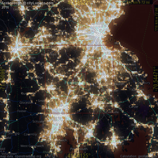
Analysis of Foxborough night lights 2016
Square area 10x10 km:
 5.4%
5.4%90-99
7.3%80-89
7.14%70-79
4.76%60-69
6.35%50-59
7.62%40-49
16.19%30-39
25.56%20-29
18.73%10-19
0.95%0-9
0%Square area 50x50 km:
7.86%90-99
9.34%80-89
5.63%70-79
6.06%60-69
8.6%50-59
10.46%40-49
10.14%30-39
10.69%20-29
16.33%10-19
12.15%0-9
2.73%Clear (daylight) street map image can be seen on geolist.org.
Map coordinates:
42° 35' 6.8" North, 71° 57' 3.5" West
42° 3' 55.4" North, 71° 14' 52.2" West
41° 32' 28.5" North, 70° 32' 41" West
Some cities around Foxborough sort by population:
• Easton
10.8 km =6.7 mi,  114°
114°
• Mansfield
4.3 km =2.7 mi,  146°
146°
• Wrentham
6.6 km =4.1 mi,  271°
271°
• Norfolk
8.8 km =5.5 mi,  313°
313°
• Plainville
9.8 km =6.1 mi,  225°
225°
• Mansfield Center
5.4 km =3.4 mi, 152°
• Walpole
8.5 km =5.3 mi,  359°
359°
• Sharon
8.6 km =5.3 mi,  41°
41°
4937222 (p: 5,625)
Sources (retrieved 2019-11-25):
» Earth at Night: Flat Maps 2012, 2016