Kensington night lights from space
Night Light of Kensington (Connecticut) from space (United States) Src. Average luminocity for 10x10km area is 67.0114% and for 50x50km: 42.667%.
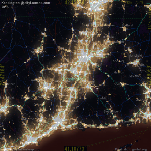
Analysis of Kensington night lights 2016
Square area 10x10 km:
 13.96%
90-99
14.77%80-89
4.87%70-79
11.85%60-69
11.69%50-59
17.21%40-49
6.33%30-39
12.99%20-29
6.33%10-19
0%0-9
0%Square area 50x50 km:
6.05%90-99
6.24%80-89
5.57%70-79
6.53%60-69
8.67%50-59
9.41%40-49
7.84%30-39
7.94%20-29
8.9%10-19
9.36%0-9
23.5%Clear (daylight) street map image can be seen on geolist.org.
Map coordinates:
42° 9' 31.5" North, 73° 28' 18.6" West
41° 38' 7.4" North, 72° 46' 7.4" West
41° 6' 27.8" North, 72° 3' 56.1" West
Some cities around Kensington sort by population:
• New Britain
3 km =1.9 mi,  342°
342°
• Meriden
11.3 km =7 mi,  196°
196°
• Middletown
12.7 km =7.9 mi,  129°
129°
• Newington
7.9 km =4.9 mi,  28°
28°
• Farmington
10.8 km =6.7 mi,  330°
330°
• Plainville
8.6 km =5.3 mi,  300°
300°
• Cromwell
11.2 km =7 mi,  113°
113°
• Portland
12.7 km =7.9 mi,  123°
123°
4837222 (p: 8,459)
Sources (retrieved 2019-11-25):
» Earth at Night: Flat Maps 2012, 2016