Pinecrest night lights from space
Night Light of Pinecrest (Florida) from space (United States) Src. Average luminocity for 10x10km area is 86.0833% and for 50x50km: 50.1361%.
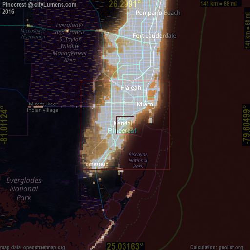
Analysis of Pinecrest night lights 2016
Square area 10x10 km:
 32.39%
90-99
28.98%80-89
16.86%70-79
3.79%60-69
6.63%50-59
2.65%40-49
3.22%30-39
2.08%20-29
3.03%10-19
0.38%0-9
0%Square area 50x50 km:
22.62%90-99
9.27%80-89
2.52%70-79
2.82%60-69
9.17%50-59
5.1%40-49
4.35%30-39
3.59%20-29
4.29%10-19
6.67%0-9
29.59%Clear (daylight) street map image can be seen on geolist.org.
Map coordinates:
26° 17' 56.8" North, 81° 0' 40.5" West
25° 40' 1.4" North, 80° 18' 29.2" West
25° 1' 53.9" North, 79° 36' 18" West
Some cities around Pinecrest sort by population:
• Kendall
1.6 km =1 mi,  325°
325°
• Coral Gables
7.2 km =4.5 mi,  33°
33°
• Palmetto Bay
5.3 km =3.3 mi,  198°
198°
• Coconut Grove
7.2 km =4.5 mi,  45°
45°
• Cutler
5.8 km =3.6 mi,  182°
182°
• Glenvar Heights
4.8 km =3 mi,  338°
338°
• Sunset
6.2 km =3.9 mi,  314°
314°
• South Miami
4.7 km =2.9 mi,  18°
18°
4168590 (p: 19,452)
Sources (retrieved 2019-11-25):
» Earth at Night: Flat Maps 2012, 2016