Sunset night lights from space
Night Light of Sunset (Florida) from space (United States) Src. Average luminocity for 10x10km area is 99.1383% and for 50x50km: 52.9198%.
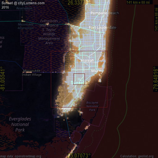
Analysis of Sunset night lights 2016
Square area 10x10 km:
 77.84%
90-99
19.7%80-89
2.46%70-79
0%60-69
0%50-59
0%40-49
0%30-39
0%20-29
0%10-19
0%0-9
0%Square area 50x50 km:
25.1%90-99
9.48%80-89
2.52%70-79
3.27%60-69
9.18%50-59
5.1%40-49
4.4%30-39
3.46%20-29
3.85%10-19
5.76%0-9
27.87%Clear (daylight) street map image can be seen on geolist.org.
Map coordinates:
26° 20' 16" North, 81° 3' 19.5" West
25° 42' 21.4" North, 80° 21' 8.2" West
25° 4' 14.6" North, 79° 38' 57" West
Some cities around Sunset sort by population:
• Kendall
4.6 km =2.9 mi,  130°
130°
• Kendale Lakes
5.5 km =3.4 mi,  272°
272°
• Westchester
6 km =3.7 mi,  24°
24°
• University Park
4.8 km =3 mi,  341°
341°
• Glenvar Heights
2.7 km =1.7 mi,  86°
86°
• Olympia Heights
2.3 km =1.4 mi,  352°
352°
• South Miami
5.9 km =3.7 mi, 88°
• Westwood Lake
3.3 km =2.1 mi,  321°
321°
4174425 (p: 16,389)
Sources (retrieved 2019-11-25):
» Earth at Night: Flat Maps 2012, 2016