Cutler night lights from space
Night Light of Cutler (Florida) from space (United States) Src. Average luminocity for 10x10km area is 64.6515% and for 50x50km: 43.5082%.
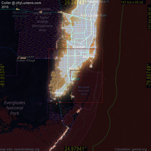
Analysis of Cutler night lights 2016
Square area 10x10 km:
 14.77%
90-99
18.37%80-89
14.77%70-79
3.98%60-69
8.52%50-59
4.36%40-49
7.58%30-39
3.98%20-29
10.42%10-19
10.04%0-9
3.22%Square area 50x50 km:
18.08%90-99
8.19%80-89
2.21%70-79
2.37%60-69
8.79%50-59
4.85%40-49
4.03%30-39
3.33%20-29
4.28%10-19
7.71%0-9
36.16%Clear (daylight) street map image can be seen on geolist.org.
Map coordinates:
26° 14' 50.7" North, 81° 0' 49.5" West
25° 36' 54.4" North, 80° 18' 38.2" West
24° 58' 45.9" North, 79° 36' 27" West
Some cities around Cutler sort by population:
• Kendall
7.2 km =4.5 mi,  354°
354°
• Palmetto Bay
1.6 km =1 mi,  297°
297°
• Pinecrest
5.8 km =3.6 mi,  2°
2°
• Palmetto Estates
5.2 km =3.2 mi,  277°
277°
• Lakes by the Bay
5 km =3.1 mi,  197°
197°
• West Perrine
5.3 km =3.3 mi,  258°
258°
• Richmond Heights
6.1 km =3.8 mi,  287°
287°
• East Perrine
2.9 km =1.8 mi, 255°
4152564 (p: 18,117)
Sources (retrieved 2019-11-25):
» Earth at Night: Flat Maps 2012, 2016