Pike Road night lights from space
Night Light of Pike Road (Alabama) from space (United States) Src. Average luminocity for 10x10km area is 15.6758% and for 50x50km: 19.0118%.
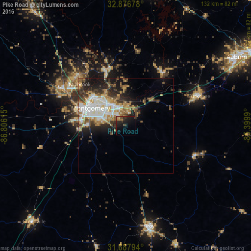
Analysis of Pike Road night lights 2016
Square area 10x10 km:
 0.18%
0.18%90-99
0.73%80-89
1.65%70-79
2.56%60-69
2.56%50-59
0.92%40-49
2.38%30-39
4.58%20-29
8.24%10-19
22.53%0-9
53.66%Square area 50x50 km:
3.89%90-99
3.81%80-89
2.64%70-79
2.34%60-69
2.65%50-59
1.94%40-49
2.12%30-39
3.24%20-29
4.56%10-19
7.05%0-9
65.74%Clear (daylight) street map image can be seen on geolist.org.
Map coordinates:
32° 52' 36.4" North, 86° 48' 22.1" West
32° 17' 3.5" North, 86° 6' 10.9" West
31° 41' 16.6" North, 85° 23' 59.6" West
Some cities around Pike Road sort by population:
• Montgomery
20.7 km =12.9 mi,  296°
296°
• Auburn
68.7 km =42.7 mi,  58°
58°
• Prattville
39 km =24.2 mi, 300°
• Troy
54.3 km =33.7 mi,  166°
166°
• Millbrook
32.6 km =20.3 mi,  311°
311°
• Tuskegee
41.7 km =25.9 mi,  68°
68°
• Wetumpka
30.6 km =19 mi,  340°
340°
• Greenville
70.1 km =43.6 mi,  223°
223°
4083073 (p: 8,274)
Sources (retrieved 2019-11-25):
» Earth at Night: Flat Maps 2012, 2016